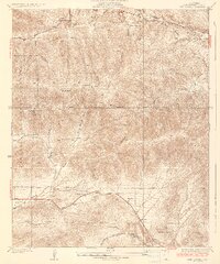
1937 Map of Red Rover
USGS Topo · Published 1937About this map
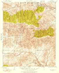
Mining and ranching activity define the high-desert landscape of northern Los Angeles County on the Sierra Pelona range. During the 1930s, the rugged canyons were home to established operations like the Puritan Mine and Red Rover Mine, alongside isolated homesteads such as Ritter Ranch, Letteau Ranch, and Hauser Ranch. The Sierra Highway and Bouquet Canyon Road serve as primary arteries through the terrain, connecting the valley floors to the higher elevations of Mt McDill. Water sources, critical in this arid environment, are noted at Fryingpan Springs and Boiling Point. A portion of the Angeles National Forest covers the western half of the sheet, where the First Standard Parallel North cuts across the steep ridges. The map captures a moment when traditional land use—cattle ranching and hard-rock mining—still dictated the settlement patterns of the Anaverde Valley.
Find a feature on this map
30 named features on this map. Tap any name to fly to it.
Don’t see what you’re looking for? This feature index may not catch every label — zoom into the map to look around manually.
Map Details
Editions of this 1937 Red Rover Map
5 editions found
Other maps of this area

1900 · Tujunga
USGS Topo · 1:62,500

1900 · Fernando
USGS Topo · 1:62,500

1901 · Southern California Sheet No. 1
USGS Topo · 1:250,000

1904 · Southern California Sheet No. 1
USGS Topo · 1:250,000

1915 · Elizabeth Lake
USGS Topo · 1:125,000

1917 · Elizabeth Lake
USGS Topo · 1:125,000

1929 · Lang
USGS Topo · 1:24,000

1930 · Ravenna
USGS Topo · 1:24,000

1930 · Lancaster
USGS Topo · 1:24,000

1931 · Del Sur
USGS Topo · 1:24,000