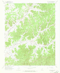
1968 Map of Red Slide Peak
USGS Topo · Published 1972About this map
The Navajo Hopi Joint Use Area dominates this late-1960s landscape, a territory defined by expansive valleys and seasonal watercourses. The local administration and community center at Forest Lake Chapter House serves as a primary hub of activity near the East Fork Dinnebito Wash. The terrain is marked by distinctive geological formations such as Red Slide Peak and Burning Rock, while the presence of the Sheep Dip Well and Reed Windmill reflects the region's reliance on managed water sources for livestock and local needs. Numerous named drainages, including Toh Ne Zhonnie Wash and Red Slide Wash, carve through the complex system of valleys like Many Greasewood Valley and Sweathouse Valley, illustrating the intricate natural drainage patterns of this high-desert environment.
Find a feature on this map
19 named features on this map. Tap any name to fly to it.
Don’t see what you’re looking for? This feature index may not catch every label — zoom into the map to look around manually.
Map Details
Editions of this 1968 Red Slide Peak Map
This is the sole edition of this map. No revisions or reprints were ever made.
Other maps of this area

1883 · Marsh Pass
USGS Topo · 1:250,000

1892 · Marsh Pass
USGS Topo · 1:250,000

1956 · Marble Canyon
USGS Topo · 1:250,000

1959 · Marble Canyon
USGS Topo · 1:250,000

1961 · Marble Canyon
USGS Topo · 1:250,000
1967 · Big Mountain Dam
USGS Topo · 1:24,000
1967 · Pinon NW
USGS Topo · 1:24,000
1967 · Coat Spring
USGS Topo · 1:24,000
1968 · Owl Valley
USGS Topo · 1:24,000
1968 · Toh Ne Zhonnie Spring
USGS Topo · 1:24,000