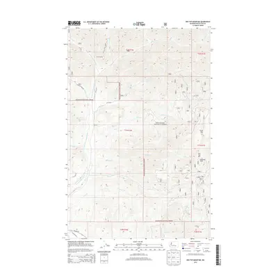
2014 Map of Red Top Mountain
USGS Topo · Published 2014About this map
The Wenatchee National Forest dominates this section of the Central Cascades, where the North Fork Teanaway River and its numerous tributaries have carved a complex system of ridges and valleys. Prominent high points like Red Top Mtn and the long spine of Teanaway Ridge define the local topography, which is largely accessed by forest roads such as NFD 9737 RD and NFD 9738 RD. Atop the heights, Stafford Lookout provided a critical vantage point for fire management within the timberlands.
Find a feature on this map
36 named features on this map. Tap any name to fly to it.
Don’t see what you’re looking for? This feature index may not catch every label — zoom into the map to look around manually.
Map Details
Editions of this 2014 Red Top Mountain Map
This is the sole edition of this map. No revisions or reprints were ever made.
Other maps of this area

1897 · Mount Stuart
USGS Topo · 1:125,000

1902 · Mount Stuart
USGS Topo · 1:125,000

1957 · Wenatchee
USGS Topo · 1:250,000

1958 · Thorp
USGS Topo · 1:62,500

1958 · Cle Elum
USGS Topo · 1:62,500

1961 · Liberty
USGS Topo · 1:62,500

1961 · Mount Stuart
USGS Topo · 1:62,500

1975 · Wenatchee
USGS Topo · 1:100,000
1984 · Cle Elum
USGS Topo · 1:24,000
1985 · Swauk Prairie
USGS Topo · 1:24,000