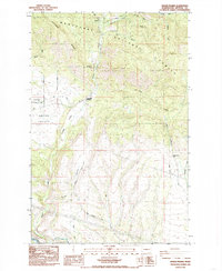
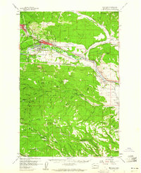
1985 Map of Swauk Prairie
USGS Topo · Published 1985About this map
Swauk Prairie occupies a distinct plateau in Kittitas County, where the transition from forest to valley floor is marked by the Wenatchee National Forest and the prominent Teanaway Ridge. This mid-1980s landscape reflects a history of small-scale mountain settlement and resource use, centered around the community of Liberty and the intersection at Lauderdale Junction. The terrain is deeply incised by numerous gulches and canyons, including Robinson Gulch and Horse Canyon, which drain into the southern Yakima River corridor. Genealogists and local historians can locate the Swauk Prairie Cem and remnants of local industry, such as a Quarry near the river. The map also records rural landmarks like the Green Canyon Ranch and the winding course of Swauk Creek, illustrating the remote but established nature of these Kittitas mountain foothills.
Find a feature on this map
26 named features on this map. Tap any name to fly to it.
Don’t see what you’re looking for? This feature index may not catch every label — zoom into the map to look around manually.
Map Details
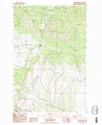
Editions of this 1985 Swauk Prairie Map
2 editions found
Other maps of this area

1897 · Mount Stuart
USGS Topo · 1:125,000

1902 · Mount Stuart
USGS Topo · 1:125,000

1957 · Wenatchee
USGS Topo · 1:250,000
1958 · Thorp
USGS Topo · 1:24,000
1958 · Thorp
USGS Topo · 1:62,500
1958 · Cle Elum
USGS Topo · 1:62,500
1958 · Ellensburg North
USGS Topo · 1:24,000
1961 · Liberty
USGS Topo · 1:62,500
1961 · Mount Stuart
USGS Topo · 1:62,500

1975 · Wenatchee
USGS Topo · 1:100,000