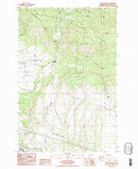
1985 Map of Swauk Prairie
USGS Topo · Published 1985About this map
Swauk Prairie sits at the foot of Teanaway Ridge, where the complex drainage of the Wenatchee National Forest meets the agricultural lands of Kittitas County. This mid-1980s data shows a landscape transitioning from the steep gulches of the north—such as Pine Gulch and Harkness Gulch—into the irrigated valley floor. The settlement of Liberty and the crossroads at Lauderdale Junction anchor the northern corridor, while the southern edge is defined by the Yakima River and the infrastructure of the North Branch Canal. Transport and utility networks are prominent, including the Burlington Northern railroad and a Steel Tower Transmission Line cutting across the eastern canyons. For genealogists, the Swauk Prairie Cem provides a specific point of local historical continuity amidst the shifting terrain of Hidden Valley and Horse Canyon.
Find a feature on this map
30 named features on this map. Tap any name to fly to it.
Don’t see what you’re looking for? This feature index may not catch every label — zoom into the map to look around manually.
Map Details
Editions of this 1985 Swauk Prairie Map
2 editions found
Other maps of this area

1897 · Mount Stuart
USGS Topo · 1:125,000

1902 · Mount Stuart
USGS Topo · 1:125,000

1957 · Wenatchee
USGS Topo · 1:250,000

1958 · Thorp
USGS Topo · 1:24,000

1958 · Thorp
USGS Topo · 1:62,500

1958 · Cle Elum
USGS Topo · 1:62,500
1958 · Ellensburg North
USGS Topo · 1:24,000

1961 · Liberty
USGS Topo · 1:62,500

1961 · Mount Stuart
USGS Topo · 1:62,500

1975 · Wenatchee
USGS Topo · 1:100,000