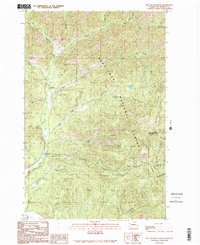
1989 Map of Red Top Mountain
USGS Topo · Published 1989About this map
Red Top Mountain and the high elevations of the Wenatchee National Forest dominate this late-twentieth-century landscape in Kittitas County. The drainage network is particularly detailed, defined by the North Fork Teanaway River and its numerous tributaries such as Jack Creek, Indian Creek, and Stafford Creek. This provisional survey shows a wilderness area managed for both conservation and recreation, evidenced by the presence of a FS Station and established campsites like 29 Pines Campground and Dickey Creek Campground. Along the eastern edge, Teanaway Ridge forms a significant topographic boundary, while the creek system—including Medicine Creek and Blue Creek—illustrates the complex watershed of the Central Cascades. The map captures the region before more modern developments, preserving the original backcountry road and trail configurations used by foresters and early outdoor enthusiasts.
Find a feature on this map
23 named features on this map. Tap any name to fly to it.
Don’t see what you’re looking for? This feature index may not catch every label — zoom into the map to look around manually.
Map Details
Editions of this 1989 Red Top Mountain Map
This is the sole edition of this map. No revisions or reprints were ever made.
Other maps of this area

1897 · Mount Stuart
USGS Topo · 1:125,000

1902 · Mount Stuart
USGS Topo · 1:125,000

1957 · Wenatchee
USGS Topo · 1:250,000

1958 · Thorp
USGS Topo · 1:62,500

1958 · Cle Elum
USGS Topo · 1:62,500

1961 · Liberty
USGS Topo · 1:62,500

1961 · Mount Stuart
USGS Topo · 1:62,500

1975 · Wenatchee
USGS Topo · 1:100,000
1984 · Cle Elum
USGS Topo · 1:24,000
1985 · Swauk Prairie
USGS Topo · 1:24,000