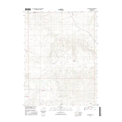
2017 Map of Red Wash NW
USGS Topo · Published 2017About this map
Deadman Bench dominates the central portion of this Uintah County landscape, an area characterized by arid plateaus and intermittent drainage systems. Sparse water resources are centered around Wooley Reservoir in the east and the isolated Glen Spring to the south. This terrain is part of a complex grid of Bureau of Land Management survey lines, including t7s r22e and t8s r22e, which organize the remote territory. The map reveals an intricate network of numbered access roads like 004531 and 222312 that traverse the benches and dips into Antelope Draw. This infrastructure highlights the region's significance for land management and resource exploration, providing a detailed view of the high desert's topography between Glen Bench and the surrounding draws.
Find a feature on this map
40 named features on this map. Tap any name to fly to it.
Don’t see what you’re looking for? This feature index may not catch every label — zoom into the map to look around manually.
Map Details
Editions of this 2017 Red Wash NW Map
This is the sole edition of this map. No revisions or reprints were ever made.
Other maps of this area

1885 · Ashley
USGS Topo · 1:250,000

1907 · Jensen
USGS Topo · 1:125,000

1910 · Jensen
USGS Topo · 1:125,000

1917 · Vernal
USGS Topo · 1:125,000

1954 · Vernal
USGS Topo · 1:250,000

1958 · Vernal
USGS Topo · 1:250,000

1960 · Vernal
USGS Topo · 1:250,000

1964 · Brennan Basin
USGS Topo · 1:24,000
1964 · Ouray SE
USGS Topo · 1:24,000
1964 · Vernal SE
USGS Topo · 1:24,000