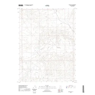
2020 Map of Red Wash NW
USGS Topo · Published 2020About this map
Deadman Bench dominates the central landscape of this Uintah County survey, illustrating the high desert topography characteristic of this part of Utah. The area is defined by its dramatic bench formations and seasonal drainage patterns, with Glen Bench appearing in the southeast corner. Human presence is light but documented by the inclusion of Stirrup Rd, a primary access route through the arid terrain. The mapping of Glen Spring indicates a critical water source in an otherwise parched environment, a feature of immense value to the cattle ranching and energy industries that operate in these remote basins. The map provides a precise layout of the township and range system, including sections 1 through 36, which underpins land ownership and resource management in this region.
Find a feature on this map
4 named features on this map. Tap any name to fly to it.
Don’t see what you’re looking for? This feature index may not catch every label — zoom into the map to look around manually.
Map Details
Editions of this 2020 Red Wash NW Map
This is the sole edition of this map. No revisions or reprints were ever made.
Other maps of this area

1885 · Ashley
USGS Topo · 1:250,000

1907 · Jensen
USGS Topo · 1:125,000

1910 · Jensen
USGS Topo · 1:125,000

1917 · Vernal
USGS Topo · 1:125,000

1954 · Vernal
USGS Topo · 1:250,000

1958 · Vernal
USGS Topo · 1:250,000

1960 · Vernal
USGS Topo · 1:250,000

1964 · Brennan Basin
USGS Topo · 1:24,000
1964 · Ouray SE
USGS Topo · 1:24,000
1964 · Vernal SE
USGS Topo · 1:24,000