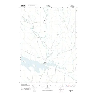
2010 Map of Redfield
USGS Topo · Published 2010About this map
The Salmon River Reservoir dominates the southern landscape of this region, its waters surrounding Burdick Island and reaching west toward Huckleberry Island. The settlement of Redfield sits at the northern edge of the reservoir, serving as a focal point for the surrounding rural roads and the local Myrtle Cemetery. This area is defined by a dense network of waterways, with the Mad River and its Mad River Falls flowing south to meet the North Branch Salmon River. Further north, the small community of Otto Mills represents the historic connection between local industry and the river system. The terrain is marked by numerous smaller tributaries like Beaver Creek, Rat Creek, and Grindstone Brook, illustrating the complex drainage of the Tug Hill region as it appeared in the early 21st century.
Find a feature on this map
43 named features on this map. Tap any name to fly to it.
Don’t see what you’re looking for? This feature index may not catch every label — zoom into the map to look around manually.
Map Details
Editions of this 2010 Redfield Map
This is the sole edition of this map. No revisions or reprints were ever made.
Other maps of this area

1903 · Orwell
USGS Topo · 1:62,500

1905 · Orwell
USGS Topo · 1:62,500

1905 · Taberg
USGS Topo · 1:62,500

1906 · Highmarket
USGS Topo · 1:62,500

1906 · Kasoag
USGS Topo · 1:62,500

1942 · Redfield
USGS Topo · 1:24,000
1943 · Boylston
USGS Topo · 1:31,680

1943 · Redfield
USGS Topo · 1:31,680

1943 · Westdale
USGS Topo · 1:31,680

1943 · East Florence
USGS Topo · 1:31,680