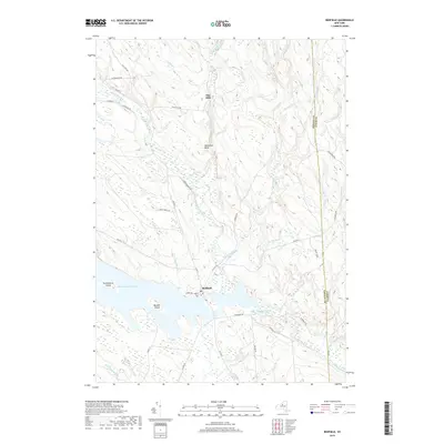
2019 Map of Redfield
USGS Topo · Published 2019About this map
Redfield sits at the northern edge of the Salmon River Reservoir, where the North Branch Salmon River feeds into the expansive waters. This landscape is defined by its complex network of tributaries, including the Mad River, Mill Stream, and Muddy Brook, which carve through the terrain of the Tug Hill region. The settlement pattern reflects a history of small woodland communities like Otto Mills, while local heritage is preserved at Myrtle Cem near the town center. The reservoir itself is punctuated by named landforms such as Burdick Island and Huckleberry Island, illustrating the topography before the valley was flooded. A web of local routes like Old State Rd and Harvester Mill Rd provides access to these forested uplands along the Oswego and Lewis county line.
Find a feature on this map
49 named features on this map. Tap any name to fly to it.
Don’t see what you’re looking for? This feature index may not catch every label — zoom into the map to look around manually.
Map Details
Editions of this 2019 Redfield Map
This is the sole edition of this map. No revisions or reprints were ever made.
Other maps of this area

1903 · Orwell
USGS Topo · 1:62,500

1905 · Orwell
USGS Topo · 1:62,500

1905 · Taberg
USGS Topo · 1:62,500

1906 · Highmarket
USGS Topo · 1:62,500

1906 · Kasoag
USGS Topo · 1:62,500

1942 · Redfield
USGS Topo · 1:24,000
1943 · Boylston
USGS Topo · 1:31,680

1943 · Redfield
USGS Topo · 1:31,680

1943 · Westdale
USGS Topo · 1:31,680

1943 · East Florence
USGS Topo · 1:31,680