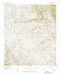
1957 Map of Redington
USGS Topo · Published 1961About this map
The San Pedro River corridor serves as the primary artery for settlement through this desert landscape, where cattle ranching defines the mid-century economy. Concentrated near the valley floor, a network of family-held properties including Bingham Ranch, Spear Ranch, and Cascabel Ranch line the river banks. The small community of Cascabel is anchored by the Cascabel School, while the northern settlement of Redington sits at the base of the rising terrain.
Find a feature on this map
79 named features on this map. Tap any name to fly to it.
Don’t see what you’re looking for? This feature index may not catch every label — zoom into the map to look around manually.
Map Details
Editions of this 1957 Redington Map
3 editions found

Other maps of this area

1904 · Tucson
USGS Topo · 1:125,000

1905 · Tucson
USGS Topo · 1:125,000

1911 · Winkelman
USGS Topo · 1:125,000

1913 · Winkelman
USGS Topo · 1:125,000

1938 · Galiuro Mts
USGS Topo · 1:48,000

1940 · Sierra Bonita Ranch
USGS Topo · 1:62,500

1942 · Sierra Bonita Ranch
USGS Topo · 1:62,500

1943 · Galiuro Mts
USGS Topo · 1:62,500

1943 · Dragoon
USGS Topo · 1:62,500

1943 · Sierra Bonita Ranch
USGS Topo · 1:62,500