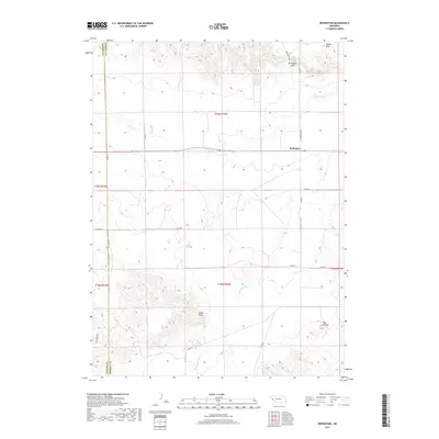
2017 Map of Redington
USGS Topo · Published 2017About this map
Redington serves as the focal point of this high-plains landscape in Morrill County, Nebraska. The community is situated along Pumpkin Cr, a significant waterway that winds through the central portion of the quadrangle. The terrain is defined by dramatic elevations and distinct landmarks typical of the region, including the prominent Redington Gap to the northeast and Round Rock at the northern edge. To the south, the drainage of Lawrence Fork carves through the land near high points like Langs Point and the Twin Mounds. A network of rural routes, such as Co RD 81 and Hackberry Rd, connects the scattered ranchlands across the Banner County and Morrill County line, illustrating the sparse but organized settlement pattern of the western Nebraska Panhandle.
Find a feature on this map
23 named features on this map. Tap any name to fly to it.
Don’t see what you’re looking for? This feature index may not catch every label — zoom into the map to look around manually.
Map Details
Editions of this 2017 Redington Map
This is the sole edition of this map. No revisions or reprints were ever made.
Other maps of this area

1898 · Camp Clarke
USGS Topo · 1:125,000

1954 · Scottsbluff
USGS Topo · 1:250,000

1958 · Scottsbluff
USGS Topo · 1:250,000

1965 · Bridgeport NW
USGS Topo · 1:24,000

1965 · South Bayard
USGS Topo · 1:24,000

1965 · McGrew
USGS Topo · 1:24,000

1972 · Horsehead Ranch
USGS Topo · 1:24,000

1973 · Bridgeport SW
USGS Topo · 1:24,000

1973 · Potter 2 NW
USGS Topo · 1:24,000
1973 · Potter 2 NE
USGS Topo · 1:24,000