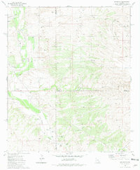
1981 Map of Redington
USGS Topo · Published 1981About this map
The San Pedro River valley defines this desert landscape, where the confluence of several major drainages supported a series of ranching outposts in the early 1980s. The settlement of Redington serves as the focal point, situated near the junction of Edgar Canyon and the river's fertile floodplain. Notable land use patterns are visible through the inclusion of the Bingham Ranch and Bayless Ranch, indicating the persistent cattle-ranching heritage of this Pima County corridor.
Find a feature on this map
31 named features on this map. Tap any name to fly to it.
Don’t see what you’re looking for? This feature index may not catch every label — zoom into the map to look around manually.
Map Details
Editions of this 1981 Redington Map
2 editions found
Other maps of this area

1904 · Tucson
USGS Topo · 1:125,000

1905 · Tucson
USGS Topo · 1:125,000

1911 · Winkelman
USGS Topo · 1:125,000

1913 · Winkelman
USGS Topo · 1:125,000

1938 · Galiuro Mts
USGS Topo · 1:48,000

1943 · Galiuro Mts
USGS Topo · 1:62,500

1945 · Redington
USGS Topo · 1:62,500

1948 · Mammoth
USGS Topo · 1:62,500

1948 · Peppersauce Wash
USGS Topo · 1:24,000
1949 · Peppersauce Wash
USGS Topo · 1:24,000