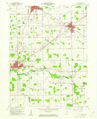
1960 Map of Redkey
USGS Topo · Published 1962About this map
The Mississinewa River winds through the southern half of this landscape, anchoring a rural territory where the borders of Delaware, Jay, and Randolph counties converge. Industrial and agricultural life in the early 1960s is defined by the intersection of rail and road, with the New York Chicago and St Louis Railroad and the Pennsylvania line cutting through the towns of Dunkirk, Redkey, and Albany. Numerous small family and community landmarks are scattered across the townships, including Sugar Grove Ch and several burial grounds like Hillcrest Cem and Caylor Cem. Of particular note is the Purdue University Agriculture Experiment Station in the southeast, reflecting the region's scientific investment in local farming. A network of pipelines and occasional gas wells point to the area's subterranean resources during this era.
Find a feature on this map
37 named features on this map. Tap any name to fly to it.
Don’t see what you’re looking for? This feature index may not catch every label — zoom into the map to look around manually.
Map Details
Editions of this 1960 Redkey Map
2 editions found
Other maps of this area

1952 · Maxville
USGS Topo · 1:24,000

1952 · Muncie East
USGS Topo · 1:24,000

1952 · Farmland
USGS Topo · 1:24,000

1953 · Muncie
USGS Topo · 1:250,000

1956 · Muncie
USGS Topo · 1:250,000

1960 · Pennville
USGS Topo · 1:24,000

1960 · Hartford City East
USGS Topo · 1:24,000

1960 · Blaine
USGS Topo · 1:24,000

1960 · Eaton
USGS Topo · 1:24,000

1960 · Ridgeville
USGS Topo · 1:24,000