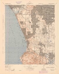
1944 Map of Redondo
USGS Topo · Published 1944About this map
Santa Monica Bay defines the western edge of this wartime landscape, where the sprawling industrialization of South Bay and the Palos Verdes Peninsula is caught mid-expansion. The map reveals a dense network of early petroleum and manufacturing infrastructure, including the Standard Oil Co Refinery at El Segundo and the Columbia Steel Corporation in Torrance. These industrial hubs are linked by the extensive Pacific Electric railway lines, which served both commuters and freight long before the freeway era dominated Los Angeles.
Find a feature on this map
75 named features on this map. Tap any name to fly to it.
Don’t see what you’re looking for? This feature index may not catch every label — zoom into the map to look around manually.
Map Details
Editions of this 1944 Redondo Map
This is the sole edition of this map. No revisions or reprints were ever made.
Other maps of this area

1894 · Los Angeles
USGS Topo · 1:62,500

1896 · Pasadena
USGS Topo · 1:62,500

1896 · Redondo
USGS Topo · 1:62,500

1896 · Las Bolsas
USGS Topo · 1:62,500

1896 · Santa Monica
USGS Topo · 1:62,500

1896 · San Pedro
USGS Topo · 1:62,500

1896 · Downey
USGS Topo · 1:62,500

1898 · Santa Monica
USGS Topo · 1:62,500

1899 · Downey
USGS Topo · 1:62,500

1900 · Pasadena
USGS Topo · 1:62,500