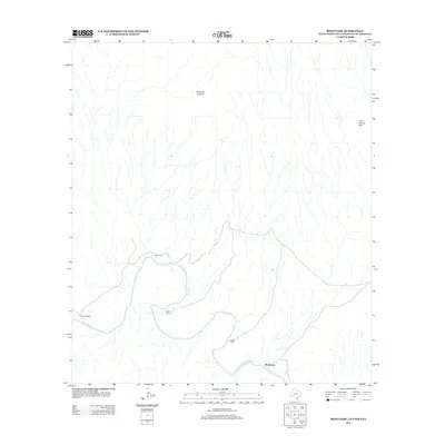
2012 Map of Reed Camp
USGS Topo · Published 2012About this map
The Rio Grande serves as the focal point of this arid borderlands landscape, carving its way past several small outposts and river camps. Woodsons anchors the southern portion of the sheet, while a string of isolated locations like Reed Camp, Jewels Camp, and Loop Camp dot the banks, reflecting the sparse but persistent human presence in this region. Away from the river, the terrain is defined by significant elevations such as Punta de la Sierra and Cow Heaven Mtn, which tower over the intricate network of dry washes and drainage patterns that feed into the river basin.
Find a feature on this map
8 named features on this map. Tap any name to fly to it.
Don’t see what you’re looking for? This feature index may not catch every label — zoom into the map to look around manually.
Map Details
Editions of this 2012 Reed Camp Map
This is the sole edition of this map. No revisions or reprints were ever made.
Other maps of this area

1903 · Chisos Mountains
USGS Topo · 1:125,000

1905 · Chisos Mountains
USGS Topo · 1:125,000

1959 · Emory Peak
USGS Topo · 1:250,000

1965 · Emory Peak
USGS Topo · 1:250,000

1971 · Glenn Spring
USGS Topo · 1:24,000

1971 · Cerro Castellan
USGS Topo · 1:24,000
1971 · Reed Camp
USGS Topo · 1:24,000
1971 · Smoky Creek
USGS Topo · 1:24,000
1971 · Emory Peak
USGS Topo · 1:24,000

1985 · Chisos Mountains
USGS Topo · 1:100,000