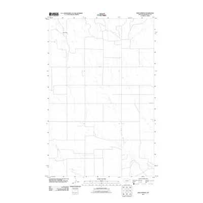
2011 Map of Reed Springs
USGS Topo · Published 2011About this map
Reed Springs serves as a central landmark in this portion of the Wolf Point District within Roosevelt County. The landscape is defined by the drainage patterns of Boxelder Creek, which meanders across the central and southern sections, and the North Fork Tule Creek in the southwest. A prominent geological feature, Castle Rock, rises in the northwest corner, providing a clear reference point in an area otherwise characterized by intermittent water sources and expansive grazing lands. Human infrastructure is represented by a sparse network of section-line roads, including Fas 250 and Benrud Rd, reflecting the large-scale agricultural and ranching operations typical of the High Plains during this period.
Find a feature on this map
6 named features on this map. Tap any name to fly to it.
Don’t see what you’re looking for? This feature index may not catch every label — zoom into the map to look around manually.
Map Details
Editions of this 2011 Reed Springs Map
This is the sole edition of this map. No revisions or reprints were ever made.
Other maps of this area

1910 · Cuskers
USGS Topo · 1:62,500

1915 · Tule Valley
USGS Topo · 1:62,500

1915 · Cuskers
USGS Topo · 1:62,500

1954 · Wolf Point
USGS Topo · 1:250,000

1958 · Wolf Point
USGS Topo · 1:250,000

1973 · Nielsen Coulee
USGS Topo · 1:24,000

1973 · Peerless 4 SE
USGS Topo · 1:24,000

1973 · Peerless 4 SW
USGS Topo · 1:24,000
1983 · Tule Valley East
USGS Topo · 1:24,000
1983 · Tule Valley West
USGS Topo · 1:24,000