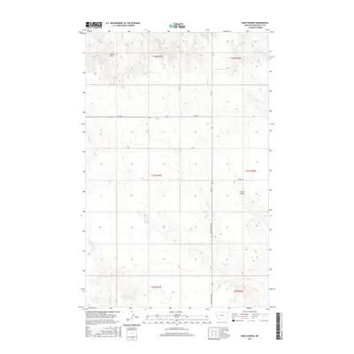
2017 Map of Reed Springs
USGS Topo · Published 2017About this map
Reed Springs and the surrounding drainage basins of Roosevelt County define this landscape as it appeared in 2017. The topography is characterized by intricate coulee systems and intermittent watercourses, such as Boxelder Cr and Smith Coulee, which carve through the high plains. A prominent landmark, Castle Rock, stands in the northwestern section of the survey, offering a distinct navigational point in an area otherwise dominated by the rhythmic contours of the Missouri River plateau. The transportation network is sparse, consisting of secondary routes like Fas 250 and Powder River Rd, which facilitate movement between rural sections. This survey provides a clear view of the ranching and agricultural infrastructure in northeastern Montana, showing how local roads like Benrud Rd follow the natural topography to connect these distant prairie reaches.
Find a feature on this map
16 named features on this map. Tap any name to fly to it.
Don’t see what you’re looking for? This feature index may not catch every label — zoom into the map to look around manually.
Map Details
Editions of this 2017 Reed Springs Map
This is the sole edition of this map. No revisions or reprints were ever made.
Other maps of this area

1910 · Cuskers
USGS Topo · 1:62,500

1915 · Tule Valley
USGS Topo · 1:62,500

1915 · Cuskers
USGS Topo · 1:62,500

1954 · Wolf Point
USGS Topo · 1:250,000

1958 · Wolf Point
USGS Topo · 1:250,000

1973 · Nielsen Coulee
USGS Topo · 1:24,000

1973 · Peerless 4 SE
USGS Topo · 1:24,000

1973 · Peerless 4 SW
USGS Topo · 1:24,000
1983 · Tule Valley East
USGS Topo · 1:24,000
1983 · Tule Valley West
USGS Topo · 1:24,000