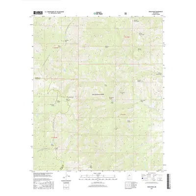
2017 Map of Reeds Peak
USGS Topo · Published 2017About this map
The Continental Divide runs through the heart of the Gila National Forest, defining the rugged hydrology of this high-elevation landscape in Grant and Sierra Counties. The Continental Divide National Scenic Trail winds along these ridgelines, passing through Reeds Meadow and connecting prominent summits such as Diamond Peak and Reeds Peak. This 2017 survey illustrates the complex drainage systems of the Black Range, where water sources like Diamond Peak Spring, Whiskey Spring, and Newman Spring provided critical points of interest for early travelers and forest rangers alike. The topography is marked by deep incisions like Moccasin John Canyon and Rattlesnake Canyon, which carve through timbered slopes and grassy openings like Turkey Park.
Find a feature on this map
47 named features on this map. Tap any name to fly to it.
Don’t see what you’re looking for? This feature index may not catch every label — zoom into the map to look around manually.
Map Details
Editions of this 2017 Reeds Peak Map
This is the sole edition of this map. No revisions or reprints were ever made.
Other maps of this area

1949 · Lookout Mountain
USGS Topo · 1:62,500

1954 · Tularosa
USGS Topo · 1:250,000

1958 · Tularosa
USGS Topo · 1:250,000

1963 · Bonner Canyon
USGS Topo · 1:24,000

1963 · Reeds Peak
USGS Topo · 1:24,000
1963 · Hay Mesa
USGS Topo · 1:24,000

1963 · Sugarloaf Peak
USGS Topo · 1:24,000

1963 · Victoria Park
USGS Topo · 1:24,000

1963 · Apache Peak
USGS Topo · 1:24,000

1965 · Winston
USGS Topo · 1:24,000