
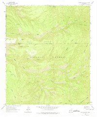
1963 Map of Bonner Canyon
USGS Topo · Published 1965About this map
The Continental Divide winds through this high-elevation wilderness within the Gila National Forest, marking a fundamental hydrological split in the American Southwest. This 1963 survey captures a landscape defined by complex drainage systems and isolated cattle-tanks, essential infrastructure for the region's ranching history. Distinctive local names like Rastus Flats, Me Own Hill, and Diamond Bar point to early land use and personal claims in this corner of Grant County. The topography is deeply incised by significant watercourses including South Diamond Creek, Bonner Canyon, and Black Canyon, which flow between prominent peaks like Spring Mountain and Aspen Mtn. In the far south, the headwaters of the Mimbres R begin their descent, illustrating the varied terrain where Sierra, Grant, and Catron counties meet.
Find a feature on this map
26 named features on this map. Tap any name to fly to it.
Don’t see what you’re looking for? This feature index may not catch every label — zoom into the map to look around manually.
Map Details
Editions of this 1963 Bonner Canyon Map
2 editions found
Other maps of this area

1911 · Alum Mountain
USGS Topo · 1:125,000

1913 · Alum Mountain
USGS Topo · 1:125,000

1949 · Lookout Mountain
USGS Topo · 1:62,500

1954 · Tularosa
USGS Topo · 1:250,000

1954 · Clifton
USGS Topo · 1:250,000

1957 · Clifton
USGS Topo · 1:250,000

1958 · Clifton
USGS Topo · 1:250,000

1958 · Tularosa
USGS Topo · 1:250,000

1962 · Clifton
USGS Topo · 1:250,000

1963 · Reeds Peak
USGS Topo · 1:24,000