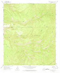
1963 Map of Bonner Canyon
USGS Topo · Published 1974About this map
The Continental Divide cuts across this high-elevation landscape within the Gila National Forest, defining the hydrological split of the American Southwest. The terrain is characterized by a complex network of drainages, including the deep Bonner Canyon and Black Canyon, where the prominent Black Canyon Box and Falls mark significant geographical breaks. In this arid environment, human presence is traced through water management features such as Me Own Tank, Meason Tank, Alligator Tank, and Polecat Tank, which likely served livestock or forest management needs during the early 1960s.
Find a feature on this map
33 named features on this map. Tap any name to fly to it.
Don’t see what you’re looking for? This feature index may not catch every label — zoom into the map to look around manually.
Map Details
Editions of this 1963 Bonner Canyon Map
2 editions found
Other maps of this area

1911 · Alum Mountain
USGS Topo · 1:125,000

1913 · Alum Mountain
USGS Topo · 1:125,000

1949 · Lookout Mountain
USGS Topo · 1:62,500

1954 · Tularosa
USGS Topo · 1:250,000

1954 · Clifton
USGS Topo · 1:250,000

1957 · Clifton
USGS Topo · 1:250,000

1958 · Clifton
USGS Topo · 1:250,000

1958 · Tularosa
USGS Topo · 1:250,000

1962 · Clifton
USGS Topo · 1:250,000

1963 · Bonner Canyon
USGS Topo · 1:24,000