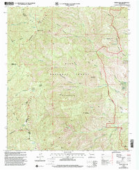
1999 Map of Reeds Peak
USGS Topo · Published 2002About this map
The Continental Divide winds through this high-elevation landscape within the Gila National Forest, tracing the crest of the Black Range. This 1999 revision captures the wilderness character of the Aldo Leopold Wilderness and the Black Range Wilderness, where access is limited to the Continental Divide National Scenic Trail and the Ranger Trail. Elevations culminate at prominent summits like Reeds Peak and Diamond Peak.
Find a feature on this map
54 named features on this map. Tap any name to fly to it.
Don’t see what you’re looking for? This feature index may not catch every label — zoom into the map to look around manually.
Map Details
Editions of this 1999 Reeds Peak Map
This is the sole edition of this map. No revisions or reprints were ever made.
Other maps of this area

1949 · Lookout Mountain
USGS Topo · 1:62,500

1954 · Tularosa
USGS Topo · 1:250,000

1958 · Tularosa
USGS Topo · 1:250,000

1963 · Bonner Canyon
USGS Topo · 1:24,000

1963 · Reeds Peak
USGS Topo · 1:24,000
1963 · Hay Mesa
USGS Topo · 1:24,000

1963 · Sugarloaf Peak
USGS Topo · 1:24,000

1963 · Victoria Park
USGS Topo · 1:24,000

1963 · Apache Peak
USGS Topo · 1:24,000

1965 · Winston
USGS Topo · 1:24,000