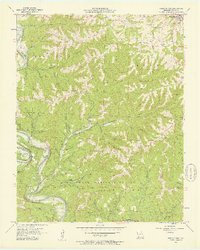
1956 Map of Reeds Spring
USGS Topo · Published 1957About this map
James River and the White River loop through a landscape of deep hollows and high bluffs in the mid-1950s, shortly before the filling of Table Rock Lake would alter the region's river valleys. The town of Reeds Spring sits at the northeast corner of this survey, which covers a significant portion of the Mark Twain National Forest. The terrain is characterized by winding drainages like Spring Creek and Ants Creek, while family-named landmarks such as Oswalt Bluff and Morris Bluff overlook the water. Genealogists will find a cluster of rural community markers, including Yocum Pond Cem, Nickerson Cem, and Sheppard Cem, alongside local gathering points like Allen Ch and the Stallion Sch. The presence of Fairy Cave and Sow Coon Mountain further illustrates the distinct karst and ridge topography of the Ozarks during this era.
Find a feature on this map
36 named features on this map. Tap any name to fly to it.
Don’t see what you’re looking for? This feature index may not catch every label — zoom into the map to look around manually.
Map Details
Editions of this 1956 Reeds Spring Map
2 editions found
Other maps of this area

1907 · Forsyth
USGS Topo · 1:125,000

1927 · Shell Knob
USGS Topo · 1:62,500

1942 · Aurora
USGS Topo · 1:62,500

1945 · Harrison
USGS Topo · 1:250,000

1945 · Aurora
USGS Topo · 1:62,500

1949 · Harrison
USGS Topo · 1:250,000

1950 · Shell Knob
USGS Topo · 1:62,500

1950 · Garber
USGS Topo · 1:24,000

1954 · Harrison
USGS Topo · 1:250,000

1956 · Lampe
USGS Topo · 1:24,000