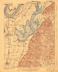
1925 Map of Reelfoot Lake
USGS Topo · Published 1925About this map
Reelfoot Lake dominates this 1920s landscape, illustrating the intricate network of basins, arms, and islands that define this earthquake-formed waterway. The survey highlights a culture shaped by the water, featuring specialized landmarks like the Hickman Hunting Club and Hickman Gun Club alongside remote landings such as Old Slough Landing and Whites Landing. To the west, the Mississippi River winds past the historic Island No 10, while the Central Illinois railroad line connects rural stations like Phillippy and Tiptonville.
Find a feature on this map
100 named features on this map. Tap any name to fly to it.
Don’t see what you’re looking for? This feature index may not catch every label — zoom into the map to look around manually.
Map Details
Editions of this 1925 Reelfoot Lake Map
3 editions found
Other maps of this area

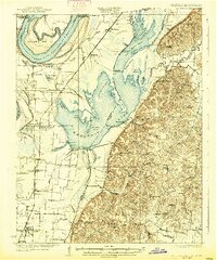
1925 · Reelfoot Lake
USGS Topo · 1:62,500

1939 · Reelfoot Lake
USGS Topo · 1:62,500

1939 · Portageville
USGS Topo · 1:62,500

1939 · Hickman
USGS Topo · 1:62,500

1939 · New Madrid
USGS Topo · 1:62,500

1939 · Bayouville
USGS Topo · 1:62,500

1939 · Dyersburg
USGS Topo · 1:62,500

1939 · Caruthersville
USGS Topo · 1:62,500

1950 · Obion
USGS Topo · 1:24,000

1951 · Obion
USGS Topo · 1:24,000