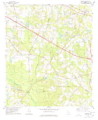
1978 Map of Register
USGS Topo · Published 1978About this map
The Central Of Georgia railroad cuts diagonally across this 1978 survey, anchoring the settlement of Register in the northeastern corner. This landscape in Bulloch County is defined by its agrarian and water-bound character, where numerous small ponds like Franklin Pond and Atwood Pond dot the terrain. The southern boundary of the map follows the winding course of the Canoochee River, where Kennedy Bridge provides a vital crossing point near the junction of Bulloch and Evans counties.
Find a feature on this map
25 named features on this map. Tap any name to fly to it.
Don’t see what you’re looking for? This feature index may not catch every label — zoom into the map to look around manually.
Map Details
Editions of this 1978 Register Map
This is the sole edition of this map. No revisions or reprints were ever made.
Other maps of this area

1919 · Claxton
USGS Topo · 1:62,500

1920 · Statesboro
USGS Topo · 1:62,500

1943 · Statesboro
USGS Topo · 1:62,500

1944 · Claxton
USGS Topo · 1:62,500

1947 · Savannah
USGS Topo · 1:250,000

1948 · Savannah
USGS Topo · 1:250,000

1950 · Claxton
USGS Topo · 1:62,500

1957 · Macon
USGS Topo · 1:250,000

1957 · Savannah
USGS Topo · 1:250,000

1958 · Macon
USGS Topo · 1:250,000