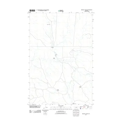
2011 Map of Regnal Coulee
USGS Topo · Published 2011About this map
71 Ranch Dam and its associated reservoir anchor the center of this Rosebud County landscape, illustrating the critical role of water management in eastern Montana’s ranching economy. The drainage network is defined by a series of north-south winding channels, including Diego Coulee and Studhorse Coulee, which eventually converge toward Regnal Coulee. This 2011 survey reveals an environment shaped by livestock operations, where intermittent water sources are captured by numerous small-scale structures. Notable among these are Coffee Number 2 Dam, Coffee Number 3 Dam, and Hunt Number 6 Dam, each marking a point of human intervention in the natural flow of Big Breed Creek and Beaverball Creek. The map provides a clear record of the section-line roads and remote prairie terrain typical of this region.
Find a feature on this map
9 named features on this map. Tap any name to fly to it.
Don’t see what you’re looking for? This feature index may not catch every label — zoom into the map to look around manually.
Map Details
Editions of this 2011 Regnal Coulee Map
This is the sole edition of this map. No revisions or reprints were ever made.
Other maps of this area

1954 · Forsyth
USGS Topo · 1:250,000

1957 · Forsyth
USGS Topo · 1:250,000

1958 · Forsyth
USGS Topo · 1:250,000

1960 · Yablonski Ranch
USGS Topo · 1:24,000

1962 · Kincheloe Ranch
USGS Topo · 1:24,000

1962 · Grebe Ranch
USGS Topo · 1:24,000

1963 · Mc Williams Springs
USGS Topo · 1:24,000

1963 · Hecker Ranch
USGS Topo · 1:24,000
1963 · Dutton Ranch
USGS Topo · 1:24,000

1963 · Regnal Coulee
USGS Topo · 1:24,000