
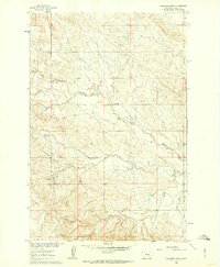
1960 Map of Yablonski Ranch
USGS Topo · Published 1962About this map
West Blacktail Creek meanders through this portion of Rosebud County, defining a landscape of ranching and homesteading in the mid-20th century. Mapped as part of the Department of the Interior's Missouri River Basin development program, the area showcases a pattern of isolated rural life centered around family holdings. Named landmarks such as the Yablonski Ranch, Finch Ranch, and Galbraith Ranch are prominently noted, alongside the Fox Homestead. These labels provide specific geographic points of interest for genealogists tracing local families or land use during this era. The presence of Edwards Road and various unimproved dirt tracks underscores the logistical challenges of the time, while the map's eastern edge points toward the Black Sea Reservoir, suggesting the importance of water management in this high-plains environment.
Find a feature on this map
11 named features on this map. Tap any name to fly to it.
Don’t see what you’re looking for? This feature index may not catch every label — zoom into the map to look around manually.
Map Details
Editions of this 1960 Yablonski Ranch Map
2 editions found
Other maps of this area

1954 · Forsyth
USGS Topo · 1:250,000

1957 · Forsyth
USGS Topo · 1:250,000

1958 · Forsyth
USGS Topo · 1:250,000

1960 · Ingomar West
USGS Topo · 1:24,000

1960 · Ingomar East
USGS Topo · 1:24,000

1960 · Black Sea Reservoir
USGS Topo · 1:24,000

1962 · Sumatra
USGS Topo · 1:24,000

1963 · Hecker Ranch
USGS Topo · 1:24,000

1963 · Regnal Coulee
USGS Topo · 1:24,000
1965 · Mc Ginnis Butte SE
USGS Topo · 1:24,000