
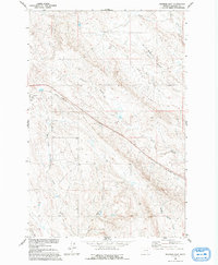
1960 Map of Ingomar East
USGS Topo · Published 1962About this map
Ingomar sits along the rail line in Rosebud County, serving as a primary settlement point in this high plains landscape during the early 1960s. The region is defined by a network of seasonal watercourses and drainage basins, most notably the East Fork Froze to Death Creek and Sun Coulee. The presence of a Claypit and scattered drill holes suggests a landscape utilized for its raw materials, while the Chicago Milwaukee St Paul and Pacific railroad provides the vital industrial link to the wider Montana territory.
Find a feature on this map
12 named features on this map. Tap any name to fly to it.
Don’t see what you’re looking for? This feature index may not catch every label — zoom into the map to look around manually.
Map Details
Editions of this 1960 Ingomar East Map
2 editions found
Other maps of this area

1954 · Forsyth
USGS Topo · 1:250,000

1957 · Forsyth
USGS Topo · 1:250,000

1958 · Forsyth
USGS Topo · 1:250,000

1960 · Steie Ranch
USGS Topo · 1:24,000

1960 · Hagen Ranch
USGS Topo · 1:24,000

1960 · Ahles
USGS Topo · 1:24,000

1960 · Yablonski Ranch
USGS Topo · 1:24,000

1960 · Thebes
USGS Topo · 1:24,000

1960 · Ingomar West
USGS Topo · 1:24,000

1960 · Black Sea Reservoir
USGS Topo · 1:24,000