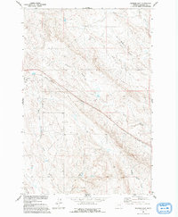
1960 Map of Ingomar East
USGS Topo · Published 1983About this map
Ingomar anchors the western edge of this Rosebud County landscape, surveyed during a period of transition for the region's transport network. A prominent Old Railroad Grade slices diagonally across the terrain, marking the path of a former rail corridor that once linked these high plains settlements. The geography is defined by a complex drainage system, most notably the colorfully named East Fork Froze To Death Creek and W Fork Froze To Death Creek, which weave through the prairie alongside Sun Coulee and Blind Coulee. Evidence of mid-century resource exploration appears in the form of several Drill Holes scattered near Geyser Spring Coulee, providing a glimpse into the geological surveying that occurred as part of the Missouri River Basin development program.
Find a feature on this map
11 named features on this map. Tap any name to fly to it.
Don’t see what you’re looking for? This feature index may not catch every label — zoom into the map to look around manually.
Map Details
Editions of this 1960 Ingomar East Map
2 editions found
Other maps of this area

1954 · Forsyth
USGS Topo · 1:250,000

1957 · Forsyth
USGS Topo · 1:250,000

1958 · Forsyth
USGS Topo · 1:250,000

1960 · Steie Ranch
USGS Topo · 1:24,000

1960 · Hagen Ranch
USGS Topo · 1:24,000

1960 · Ahles
USGS Topo · 1:24,000

1960 · Yablonski Ranch
USGS Topo · 1:24,000

1960 · Thebes
USGS Topo · 1:24,000

1960 · Ingomar West
USGS Topo · 1:24,000

1960 · Ingomar East
USGS Topo · 1:24,000