
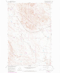
1960 Map of Ingomar West
USGS Topo · Published 1962About this map
The high plains of eastern Montana's Rosebud County are defined here by the drainage network of the West Fork Froze to Death Creek and Middle Fork Froze to Death Creek. During the early 1960s, the community of Ingomar served as a key point on the Chicago Milwaukee St Paul and Pacific railroad, which cuts diagonally across the landscape. The map captures an era of resource exploration and infrastructure maintenance, marked by scattered Drill Holes, an Oil Well, and a Gravel Pit. To the west, the station at Galbraith provides a specific point of reference for researchers tracing the historical footprint of the Milwaukee Road. The fine red dashed lines appearing throughout the survey indicate established fence and field lines, offering a glimpse into the division of ranching lands during the development of the Missouri River Basin.
Find a feature on this map
12 named features on this map. Tap any name to fly to it.
Don’t see what you’re looking for? This feature index may not catch every label — zoom into the map to look around manually.
Map Details
Editions of this 1960 Ingomar West Map
2 editions found
Other maps of this area

1954 · Forsyth
USGS Topo · 1:250,000

1957 · Forsyth
USGS Topo · 1:250,000

1958 · Forsyth
USGS Topo · 1:250,000

1960 · Steie Ranch
USGS Topo · 1:24,000

1960 · Yablonski Ranch
USGS Topo · 1:24,000

1960 · Ingomar East
USGS Topo · 1:24,000

1960 · Black Sea Reservoir
USGS Topo · 1:24,000

1960 · Mc Konkey Creek
USGS Topo · 1:24,000

1962 · Sumatra
USGS Topo · 1:24,000

1963 · Hecker Ranch
USGS Topo · 1:24,000