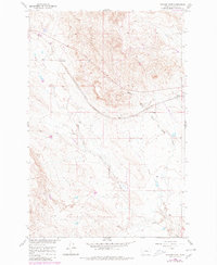
1960 Map of Ingomar West
USGS Topo · Published 1980About this map
Ingomar and Galbraith serve as the primary points of human settlement in this section of Rosebud County, Montana. The landscape is defined by the extensive drainage systems of the Middle Fork Froze to Death Creek and the West Fork Froze to Death Creek, which carve through the high plains. Running diagonally across the terrain, the Chicago Milwaukee St Paul and Pacific railroad corridor highlights the vital role of rail transport in the regional economy. This mid-century survey reflects the industrial footprint of the era, marked by a scattered Gravel Pit and exploration sites, providing a clear view of how land use and infrastructure were integrated into the northern Missouri River Basin development.
Find a feature on this map
8 named features on this map. Tap any name to fly to it.
Don’t see what you’re looking for? This feature index may not catch every label — zoom into the map to look around manually.
Map Details
Editions of this 1960 Ingomar West Map
2 editions found
Other maps of this area

1954 · Forsyth
USGS Topo · 1:250,000

1957 · Forsyth
USGS Topo · 1:250,000

1958 · Forsyth
USGS Topo · 1:250,000

1960 · Steie Ranch
USGS Topo · 1:24,000

1960 · Yablonski Ranch
USGS Topo · 1:24,000

1960 · Ingomar West
USGS Topo · 1:24,000

1960 · Ingomar East
USGS Topo · 1:24,000

1960 · Black Sea Reservoir
USGS Topo · 1:24,000

1960 · Mc Konkey Creek
USGS Topo · 1:24,000

1962 · Sumatra
USGS Topo · 1:24,000