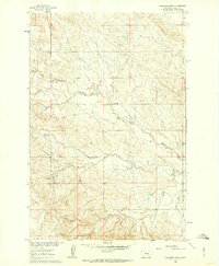
1960 Map of Yablonski Ranch
USGS Topo · Published 1962About this map
Yablonski Ranch and the nearby Finch Ranch anchor this 1960s study of the Missouri River Basin development in Rosebud County. The landscape is defined by the winding course of West Blacktail Creek, which drains a complex network of coulees and ridges typical of the Montana plains. Unlike denser agricultural regions, the settlement pattern here is characterized by isolated homesteads and ranches, including the Fox Homestead and the small locality of Galbraith in the southern portion of the quadrangle. Transport is limited to unimproved dirt tracks and the primary Edwards Road running along the eastern margin. This map documents a specific moment in the mid-century ranching economy, capturing the precise locations of residential structures and local property improvements before later consolidation changed the rural footprint.
Find a feature on this map
10 named features on this map. Tap any name to fly to it.
Don’t see what you’re looking for? This feature index may not catch every label — zoom into the map to look around manually.
Map Details
Editions of this 1960 Yablonski Ranch Map
2 editions found
Other maps of this area

1954 · Forsyth
USGS Topo · 1:250,000

1957 · Forsyth
USGS Topo · 1:250,000

1958 · Forsyth
USGS Topo · 1:250,000

1960 · Yablonski Ranch
USGS Topo · 1:24,000

1960 · Ingomar West
USGS Topo · 1:24,000

1960 · Ingomar East
USGS Topo · 1:24,000

1960 · Black Sea Reservoir
USGS Topo · 1:24,000

1962 · Sumatra
USGS Topo · 1:24,000

1963 · Hecker Ranch
USGS Topo · 1:24,000

1963 · Regnal Coulee
USGS Topo · 1:24,000