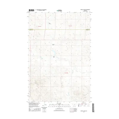
2017 Map of Regnal Coulee
USGS Topo · Published 2017About this map
Regnal Coulee and the surrounding drainage basins of eastern Montana define this landscape of high plains and sharp breaks. Situated along the boundary between Garfield and Rosebud counties, the area is characterized by isolated cattle operations and scattered water sources essential for livestock. Prominent topographic landmarks such as McGinnis Butte and McGinnis Butte SW rise above the drainage networks of Big Breed Cr and Beaverhall Cr, while numerous family-named holdings like the Dutton Ranch, Grebe Ranch, and Hecker Ranch illustrate the sparse but enduring ranching footprint. The intricate network of coulees, including Studhorse Coulee and Diego Coulee, highlights the erosional patterns of this arid environment. Key water features such as McWilliams Springs serve as vital nodes in an otherwise dry terrain, supporting the operations of the Yablonski Ranch and Kincheloe Ranch.
Find a feature on this map
19 named features on this map. Tap any name to fly to it.
Don’t see what you’re looking for? This feature index may not catch every label — zoom into the map to look around manually.
Map Details
Editions of this 2017 Regnal Coulee Map
This is the sole edition of this map. No revisions or reprints were ever made.
Other maps of this area

1954 · Forsyth
USGS Topo · 1:250,000

1957 · Forsyth
USGS Topo · 1:250,000

1958 · Forsyth
USGS Topo · 1:250,000

1960 · Yablonski Ranch
USGS Topo · 1:24,000

1962 · Kincheloe Ranch
USGS Topo · 1:24,000

1962 · Grebe Ranch
USGS Topo · 1:24,000

1963 · Mc Williams Springs
USGS Topo · 1:24,000

1963 · Hecker Ranch
USGS Topo · 1:24,000
1963 · Dutton Ranch
USGS Topo · 1:24,000

1963 · Regnal Coulee
USGS Topo · 1:24,000