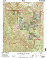
1995 Map of Reliz Canyon
USGS Topo · Published 2000About this map
Fort Hunter Liggett and the Los Padres National Forest dominate this mid-1990s survey of the Central Coast interior. The landscape is defined by the steep drainage of Reliz Canyon and its namesake Reliz Creek, where the rugged topography transitions into the protected Ventana Wilderness. Isolated family holdings like Herbert Ranch and Leigh Ranch appear alongside remnants of earlier activity, including a designated ruins site and a communication site on the ridgeline. The map captures a complex intersection of federal land management, military training grounds, and private ranching interests. Striking geological features such as The Rocks and the heights of Bear Mountain provide a clear view of the area's physical isolation and the persistence of traditional land use within the Monterey County backcountry.
Find a feature on this map
20 named features on this map. Tap any name to fly to it.
Don’t see what you’re looking for? This feature index may not catch every label — zoom into the map to look around manually.
Map Details
Editions of this 1995 Reliz Canyon Map
This is the sole edition of this map. No revisions or reprints were ever made.
Other maps of this area

1912 · Metz
USGS Topo · 1:31,680

1915 · Soledad
USGS Topo · 1:62,500

1919 · King City
USGS Topo · 1:62,500

1919 · Junipero Serra
USGS Topo · 1:62,500

1921 · Metz
USGS Topo · 1:62,500

1939 · King City
USGS Topo · 1:62,500

1940 · Metz
USGS Topo · 1:62,500

1940 · Soledad
USGS Topo · 1:62,500

1941 · Junipero Serra
USGS Topo · 1:62,500

1947 · Metz
USGS Topo · 1:62,500