
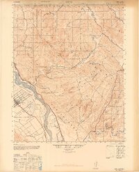
1947 Map of Metz
USGS Topo · Published 1947About this map
The Salinas Valley floor and the craggy elevations of Pinnacles National Monument dominate this mid-century survey of Monterey and San Benito Counties. The Southern Pacific railroad line runs parallel to the Salinas River, serving the small settlements of Metz and Coburn. Agriculture and ranching are clearly established across the valley and into the canyons, with several family-named landmarks such as Breen Ranch, Schmidt Ranch, and San Carlos Ranch marking the landscape. In the north, the dramatic Pinnacle Rocks and Little Pinnacles contrast sharply with the flat alluvial lands to the west. Local infrastructure is evidenced by the Metz School and an Oil Pumping Station, while the historical land division of Posa de los Ositos suggests the area's earlier heritage. The terrain transitions from the riparian corridor of the Arroyo Seco to the complex drainage systems of Topo Creek and Aqua Grande Canyon.
Find a feature on this map
48 named features on this map. Tap any name to fly to it.
Don’t see what you’re looking for? This feature index may not catch every label — zoom into the map to look around manually.
Map Details
Editions of this 1947 Metz Map
2 editions found
Other maps of this area

1912 · Metz
USGS Topo · 1:31,680

1913 · Panoche
USGS Topo · 1:125,000

1915 · Soledad
USGS Topo · 1:62,500

1915 · Priest Valley
USGS Topo · 1:125,000

1919 · King City
USGS Topo · 1:62,500

1919 · San Benito
USGS Topo · 1:62,500

1919 · Junipero Serra
USGS Topo · 1:62,500

1921 · Gonzales
USGS Topo · 1:62,500

1921 · Metz
USGS Topo · 1:62,500

1931 · San Benito
USGS Topo · 1:62,500