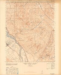
1947 Map of Metz
USGS Topo · Published 1947About this map
The rugged boundary between San Benito County and Monterey County is defined by the sharp elevations of the Gabilan Range and the sprawling Pinnacles National Monument. In the lowlands, the Salinas River valley supports a concentrated agricultural and transport corridor, where the town of Greenfield and the settlement at Metz anchor the local economy. The Southern Pacific railroad parallels the river, connecting rural sidings like Coburn and Elsa to larger markets. This 1947 survey captures a landscape of extreme transitions, from the rock formations of Little Pinnacles to the established family holdings such as the Schmidt Ranch and San Carlos Ranch. Further south, the map details the intricate canyon systems feeding into the Arroyo Seco, including Llano Grande Canyon and Aqua Grande Canyon, while an Oil Pumping Station indicates the industrial footprint of the era.
Find a feature on this map
43 named features on this map. Tap any name to fly to it.
Don’t see what you’re looking for? This feature index may not catch every label — zoom into the map to look around manually.
Map Details
Editions of this 1947 Metz Map
2 editions found

Other maps of this area

1912 · Metz
USGS Topo · 1:31,680

1913 · Panoche
USGS Topo · 1:125,000

1915 · Soledad
USGS Topo · 1:62,500

1915 · Priest Valley
USGS Topo · 1:125,000

1919 · King City
USGS Topo · 1:62,500

1919 · San Benito
USGS Topo · 1:62,500

1919 · Junipero Serra
USGS Topo · 1:62,500

1921 · Gonzales
USGS Topo · 1:62,500

1921 · Metz
USGS Topo · 1:62,500

1931 · San Benito
USGS Topo · 1:62,500