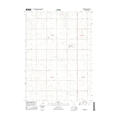
2015 Map of Rembrandt
USGS Topo · Published 2015About this map
The town of Rembrandt serves as the central hub for this corner of Buena Vista County, Iowa. Located within a landscape defined by an orderly grid of section lines and gravel roads, the settlement grew as a service point for the surrounding agricultural community. The terrain is drained by modest watercourses including Fox Run in the west and Soldier Cr to the northeast, which break the otherwise geometric regularity of the farmland. A notable site for local history and genealogy is the Little Sioux Valley Cem, situated along Co RD 55. The map meticulously details the transit network of the mid-2010s, including primary arteries like Co Hwy M36 and Co Hwy M44, as well as numerous local township roads that have connected farmsteads for generations.
Find a feature on this map
31 named features on this map. Tap any name to fly to it.
Don’t see what you’re looking for? This feature index may not catch every label — zoom into the map to look around manually.
Map Details
Editions of this 2015 Rembrandt Map
This is the sole edition of this map. No revisions or reprints were ever made.
Other maps of this area

1954 · Fort Dodge
USGS Topo · 1:250,000

1957 · Fort Dodge
USGS Topo · 1:250,000

1958 · Fort Dodge
USGS Topo · 1:250,000

1971 · Sioux Rapids SE
USGS Topo · 1:24,000

1971 · Rembrandt
USGS Topo · 1:24,000

1971 · Sioux Rapids
USGS Topo · 1:24,000

1971 · Peterson SE
USGS Topo · 1:24,000
1971 · Peterson
USGS Topo · 1:24,000

1971 · Webb
USGS Topo · 1:24,000

1979 · Storm Lake
USGS Topo · 1:24,000