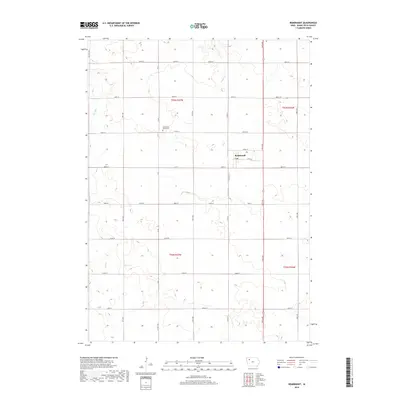
2018 Map of Rembrandt
USGS Topo · Published 2018About this map
Rembrandt serves as the central hub of this Buena Vista County landscape, where the precision of the Public Land Survey System is etched into the earth through a rigid grid of agricultural roads and section boundaries. The topography is defined by the subtle drainage patterns of Fox Run and Soldier Cr, which break the geometric regularity of the tilled fields. A notable point of local history is the Little Sioux Valley Cem, situated northwest of the town center near Co Rd 55.
Find a feature on this map
30 named features on this map. Tap any name to fly to it.
Don’t see what you’re looking for? This feature index may not catch every label — zoom into the map to look around manually.
Map Details
Editions of this 2018 Rembrandt Map
This is the sole edition of this map. No revisions or reprints were ever made.
Other maps of this area

1954 · Fort Dodge
USGS Topo · 1:250,000

1957 · Fort Dodge
USGS Topo · 1:250,000

1958 · Fort Dodge
USGS Topo · 1:250,000

1971 · Sioux Rapids SE
USGS Topo · 1:24,000

1971 · Rembrandt
USGS Topo · 1:24,000

1971 · Sioux Rapids
USGS Topo · 1:24,000

1971 · Peterson SE
USGS Topo · 1:24,000
1971 · Peterson
USGS Topo · 1:24,000

1971 · Webb
USGS Topo · 1:24,000

1979 · Storm Lake
USGS Topo · 1:24,000