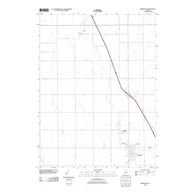
2010 Map of Remington
USGS Topo · Published 2010About this map
Remington anchors the southern portion of this Jasper County landscape, showing a dense street grid and significant agricultural infrastructure in the early 21st century. The town is flanked by the Remington Cemetery and Sacred Heart Cemetery, providing clear documentation for local genealogical research. North of the primary settlement, Fountain Park stands near the banks of Carpenter Creek, which serves as the primary natural drainage for the region.
Find a feature on this map
23 named features on this map. Tap any name to fly to it.
Don’t see what you’re looking for? This feature index may not catch every label — zoom into the map to look around manually.
Map Details
Editions of this 2010 Remington Map
This is the sole edition of this map. No revisions or reprints were ever made.
Other maps of this area

1953 · Danville
USGS Topo · 1:250,000

1955 · Danville
USGS Topo · 1:250,000

1956 · Danville
USGS Topo · 1:250,000

1961 · Mount Ayr
USGS Topo · 1:24,000

1962 · Mount Gilboa
USGS Topo · 1:24,000

1962 · Wadena
USGS Topo · 1:24,000

1962 · Templeton NE
USGS Topo · 1:24,000

1962 · Goodland
USGS Topo · 1:24,000
1962 · Mc Coysburg
USGS Topo · 1:24,000
1962 · Rensselaer
USGS Topo · 1:24,000