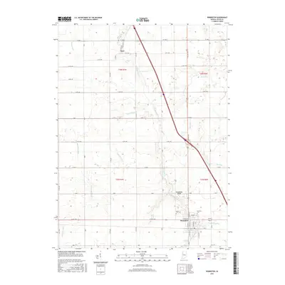
2016 Map of Remington
USGS Topo · Published 2016About this map
Remington anchors the southern portion of this landscape, showing a grid of residential streets including N Maine St and W Division St near the local rail corridor. The town's historical geography is further detailed by the presence of Remington Cem and Sacred Heart Cem on its outskirts. North of the primary settlement, the area transitions into an organized agricultural expanse defined by a sophisticated drainage network. Named waterways such as Claude May Ditch, Gushwa Ditch, and Bice Ditch reveal how the prairie lands were managed for cultivation. Scattered smaller sites like the settlement of Egypt near Welsh Cem and the recreational or community space at Fountain Park provide specific points of interest for genealogists tracking family locations across this section of Jasper County.
Find a feature on this map
38 named features on this map. Tap any name to fly to it.
Don’t see what you’re looking for? This feature index may not catch every label — zoom into the map to look around manually.
Map Details
Editions of this 2016 Remington Map
This is the sole edition of this map. No revisions or reprints were ever made.
Other maps of this area

1953 · Danville
USGS Topo · 1:250,000

1955 · Danville
USGS Topo · 1:250,000

1956 · Danville
USGS Topo · 1:250,000

1961 · Mount Ayr
USGS Topo · 1:24,000

1962 · Mount Gilboa
USGS Topo · 1:24,000

1962 · Wadena
USGS Topo · 1:24,000

1962 · Templeton NE
USGS Topo · 1:24,000

1962 · Goodland
USGS Topo · 1:24,000
1962 · Mc Coysburg
USGS Topo · 1:24,000
1962 · Rensselaer
USGS Topo · 1:24,000