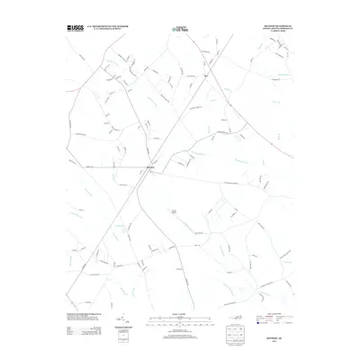
2013 Map of Rennert
USGS Topo · Published 2013About this map
Rennert and Rex anchor this part of Robeson County, where the landscape is defined by an intricate network of waterways and low-lying basins. The geography is dominated by Big Marsh Swamp, which snakes through the central portion of the map, and the curiously named Great Desert, a terrain feature situated between the drainage of Tenmile Swamp and Raft Swamp. This 2013 survey illustrates how local transportation evolved along these natural barriers, with routes like Rex Church Rd and Cedar Grove Church Rd providing connectivity between rural homesteads and agricultural centers. Smaller tributaries such as Frazier Br, Beaverdam Br, and Redden Br further dissect the land, highlighting the persistent wetness of the coastal plain. The distribution of local roads like Watts Dairy Rd and Lombardy Village Rd reflects a long-standing pattern of dispersed rural settlement in North Carolina's interior.
Find a feature on this map
114 named features on this map. Tap any name to fly to it.
Don’t see what you’re looking for? This feature index may not catch every label — zoom into the map to look around manually.
Map Details
Editions of this 2013 Rennert Map
This is the sole edition of this map. No revisions or reprints were ever made.
Other maps of this area

1953 · Florence
USGS Topo · 1:250,000

1954 · Florence
USGS Topo · 1:250,000

1957 · Bladenboro
USGS Topo · 1:62,500

1959 · Saint Pauls
USGS Topo · 1:62,500

1972 · Northwest Lumberton
USGS Topo · 1:24,000

1972 · Rennert
USGS Topo · 1:24,000
1972 · Raeford
USGS Topo · 1:24,000

1972 · Pembroke
USGS Topo · 1:24,000
1972 · Parkton
USGS Topo · 1:24,000
1974 · Red Springs
USGS Topo · 1:24,000