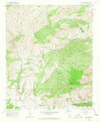
1964 Map of Reno Pass
USGS Topo · Published 1965About this map
The Mazatzal Mountains dominate this mid-century survey of the Tonto National Forest, where the intersection of Maricopa, Gila, and Yavapai counties meets a landscape defined by rugged mining activity and high-elevation utility. Mineral exploration is central to this area's history, evidenced by the Mercury Mine, Sunflower Mine, and several unnamed prospects scattered along the drainage of Slate Creek.
Find a feature on this map
50 named features on this map. Tap any name to fly to it.
Don’t see what you’re looking for? This feature index may not catch every label — zoom into the map to look around manually.
Map Details
Editions of this 1964 Reno Pass Map
3 editions found
Other maps of this area

1887 · Verde
USGS Topo · 1:250,000

1892 · Verde
USGS Topo · 1:250,000

1907 · Roosevelt
USGS Topo · 1:125,000

1909 · Four Peaks
USGS Topo · 1:125,000

1912 · Roosevelt
USGS Topo · 1:125,000

1929 · Turret Peak
USGS Topo · 1:125,000

1930 · Cave Creek
USGS Topo · 1:125,000

1933 · Turret Peak
USGS Topo · 1:125,000

1936 · Payson
USGS Topo · 1:48,000

1939 · Cave Creek
USGS Topo · 1:125,000