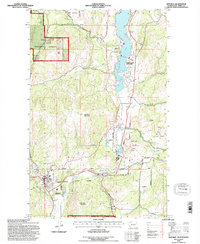
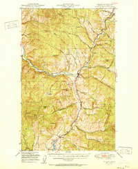
1992 Map of Republic
USGS Topo · Published 1996About this map
The town of Republic serves as a focal point in this 1990s-era survey, situated near the southwestern corner of the quadrangle. This region reflects a complex landscape defined by the mining legacy of Ferry County and the recreation-oriented waters of Curlew Lake. Evidence of local industry is visible through numerous mineshafts and prospect mines dotting the terrain east of Sanpoil Lake, particularly around the slopes of Gold Hill. The transportation history of the area is etched into the topography via the Old RR Gr, tracing a route through the hills toward Pollard. Within the Colville National Forest, the terrain rises toward significant heights like Klondike Mountain and Bald Peak, while Curlew Lake State Park highlights the transition from resource extraction to conservation. These features collectively illustrate a community deeply tied to both its mineral riches and its surrounding natural highlands.
Find a feature on this map
34 named features on this map. Tap any name to fly to it.
Don’t see what you’re looking for? This feature index may not catch every label — zoom into the map to look around manually.
Map Details
Editions of this 1992 Republic Map
This is the sole edition of this map. No revisions or reprints were ever made.
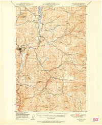
Other maps of this area

1904 · Republic
USGS Topo · 1:125,000
1948 · Curlew
USGS Topo · 1:62,500
1948 · Republic
USGS Topo · 1:62,500
1951 · Wauconda
USGS Topo · 1:62,500
1951 · Curlew
USGS Topo · 1:62,500

1951 · Bodie Mountain
USGS Topo · 1:62,500
1951 · Republic
USGS Topo · 1:62,500

1954 · Okanogan
USGS Topo · 1:250,000

1958 · Okanogan
USGS Topo · 1:250,000
1958 · Aeneas
USGS Topo · 1:62,500