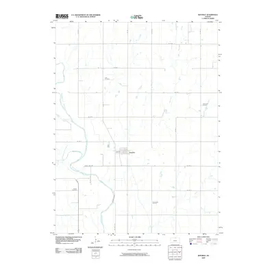
2009 Map of Republic
USGS Topo · Published 2009About this map
The Republican River winds through the western half of this North Central Kansas landscape, joined by the waters of White Rock Creek and Spring Creek. The town of Republic sits at the center of a grid-iron road network, where Main St serves as a primary local thoroughfare. The surrounding prairie is dotted with a collection of historic burial grounds that offer valuable touchpoints for genealogical research, including Lake Cemetery, Washington Cemetery, Gritten Cemetery, and Prairie Rose Cemetery. This 2009 survey reflects the enduring agricultural character of Republic County, where the terrain is defined by its drainage basins, such as Otter Creek and Dry Creek, and a strictly maintained system of county roads that have guided movement through this rural district for generations.
Find a feature on this map
28 named features on this map. Tap any name to fly to it.
Don’t see what you’re looking for? This feature index may not catch every label — zoom into the map to look around manually.
Map Details
Editions of this 2009 Republic Map
This is the sole edition of this map. No revisions or reprints were ever made.
Other maps of this area

1892 · Concordia
USGS Topo · 1:125,000

1898 · Hebron
USGS Topo · 1:125,000

1955 · Manhattan
USGS Topo · 1:250,000

1955 · Lincoln
USGS Topo · 1:250,000

1956 · Manhattan
USGS Topo · 1:250,000

1957 · Manhattan
USGS Topo · 1:250,000

1957 · Lincoln
USGS Topo · 1:250,000

1958 · Lincoln
USGS Topo · 1:250,000

1960 · Byron
USGS Topo · 1:24,000
1960 · Hebron SW
USGS Topo · 1:24,000