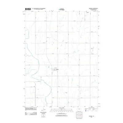
2012 Map of Republic
USGS Topo · Published 2012About this map
The Republican River winds along the western edge of this agricultural landscape in north-central Kansas, shaping the drainage of the surrounding prairie. The town of Republic serves as the central hub, organized on a grid with local landmarks such as the Po and streets including N St and S St. The survey reveals a region defined by its watercourses, including White Rock Cr, Spring Cr, and the branching arms of Otter Cr. Genealogists and local historians can locate several family and community burial grounds dispersed across the townships, such as Lake Cem to the north, Washington Cem in the east, and Prairie Rose Cem to the south. Further west near the river, Gritten Cem sits near the intersection of Co Hwy H and 50th Rd, while the settlement of Harbine marks the northern boundary of the sheet.
Find a feature on this map
35 named features on this map. Tap any name to fly to it.
Don’t see what you’re looking for? This feature index may not catch every label — zoom into the map to look around manually.
Map Details
Editions of this 2012 Republic Map
This is the sole edition of this map. No revisions or reprints were ever made.
Other maps of this area

1892 · Concordia
USGS Topo · 1:125,000

1898 · Hebron
USGS Topo · 1:125,000

1955 · Manhattan
USGS Topo · 1:250,000

1955 · Lincoln
USGS Topo · 1:250,000

1956 · Manhattan
USGS Topo · 1:250,000

1957 · Manhattan
USGS Topo · 1:250,000

1957 · Lincoln
USGS Topo · 1:250,000

1958 · Lincoln
USGS Topo · 1:250,000

1960 · Byron
USGS Topo · 1:24,000
1960 · Hebron SW
USGS Topo · 1:24,000