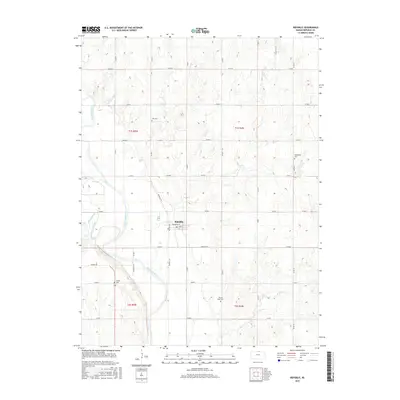
2015 Map of Republic
USGS Topo · Published 2015About this map
The settlement of Republic sits at the heart of this North Central Kansas landscape, where the Republican River winds through the western half of the territory. The town's grid is clearly defined by streets such as Main St, Broadway St, and S St, indicating a structured local center amidst a vast agricultural section-line road network. This survey captures a rural community deeply tied to its geography, with several small watercourses like Otter Cr and White Rock Creek draining into the river valley.
Find a feature on this map
32 named features on this map. Tap any name to fly to it.
Don’t see what you’re looking for? This feature index may not catch every label — zoom into the map to look around manually.
Map Details
Editions of this 2015 Republic Map
This is the sole edition of this map. No revisions or reprints were ever made.
Other maps of this area

1892 · Concordia
USGS Topo · 1:125,000

1898 · Hebron
USGS Topo · 1:125,000

1955 · Manhattan
USGS Topo · 1:250,000

1955 · Lincoln
USGS Topo · 1:250,000

1956 · Manhattan
USGS Topo · 1:250,000

1957 · Manhattan
USGS Topo · 1:250,000

1957 · Lincoln
USGS Topo · 1:250,000

1958 · Lincoln
USGS Topo · 1:250,000

1960 · Byron
USGS Topo · 1:24,000
1960 · Hebron SW
USGS Topo · 1:24,000