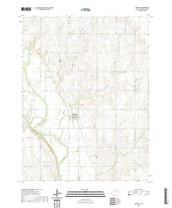
2022 Map of Republic
USGS Topo · Published 2022About this map
The town of Republic serves as the focal point of this northern Kansas survey, situated just north of the Republican River and west of Otter Cr. This agricultural landscape is defined by the grid of the Public Land Survey System, which dictates the layout of local travel routes such as Fir Rd and Republic Ln. The map documents a deeply rooted rural community, evidenced by several family or community burial grounds scattered across the townships, including Gritten Cem, Lake Cem, Prairie Rose Cem, and Washington Cem. One of the most significant historical markers on the sheet is the Pawnee Trl, which cuts across the southwestern section of the map near the river. This trail traces a long-established movement corridor through the plains, while the varied hydrography of White Rock Creek and Dry Cr illustrates the drainage patterns that have shaped regional farming and settlement for generations.
Find a feature on this map
32 named features on this map. Tap any name to fly to it.
Don’t see what you’re looking for? This feature index may not catch every label — zoom into the map to look around manually.
Map Details
Editions of this 2022 Republic Map
This is the sole edition of this map. No revisions or reprints were ever made.
Other maps of this area

1892 · Concordia
USGS Topo · 1:125,000

1898 · Hebron
USGS Topo · 1:125,000

1955 · Manhattan
USGS Topo · 1:250,000

1955 · Lincoln
USGS Topo · 1:250,000

1956 · Manhattan
USGS Topo · 1:250,000

1957 · Manhattan
USGS Topo · 1:250,000

1957 · Lincoln
USGS Topo · 1:250,000

1958 · Lincoln
USGS Topo · 1:250,000
1960 · Byron
USGS Topo · 1:24,000
1960 · Hebron SW
USGS Topo · 1:24,000