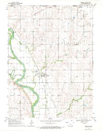
1969 Map of Republic
USGS Topo · Published 1971About this map
The Republican River carves a dramatic path through this northern Kansas landscape, forming the prominent Big Bend just west of Republic. This late 1960s survey documents a region defined by its water management and agricultural infrastructure, notably the White Rock Extension Canal with its complex system of siphons and flumes. The rail corridors of the Northern Burlington and Missouri Pacific intersect the terrain, reflecting the transportation network essential to these prairie townships.
Find a feature on this map
24 named features on this map. Tap any name to fly to it.
Don’t see what you’re looking for? This feature index may not catch every label — zoom into the map to look around manually.
Map Details
Editions of this 1969 Republic Map
This is the sole edition of this map. No revisions or reprints were ever made.
Other maps of this area

1892 · Concordia
USGS Topo · 1:125,000

1898 · Hebron
USGS Topo · 1:125,000

1955 · Manhattan
USGS Topo · 1:250,000

1955 · Lincoln
USGS Topo · 1:250,000

1956 · Manhattan
USGS Topo · 1:250,000

1957 · Manhattan
USGS Topo · 1:250,000

1957 · Lincoln
USGS Topo · 1:250,000

1958 · Lincoln
USGS Topo · 1:250,000

1960 · Byron
USGS Topo · 1:24,000
1960 · Hebron SW
USGS Topo · 1:24,000