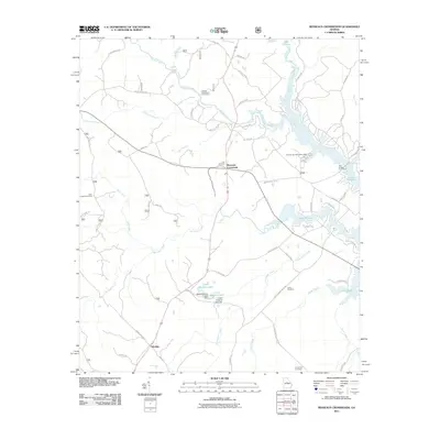
2011 Map of Resseaus Crossroads
USGS Topo · Published 2011About this map
Lake Sinclair dominates the eastern landscape of this Jones County survey, its irregular fingers reaching into the surrounding pine-strewn hills. The small community of Resseaus Crossroads sits at the center, serving as a hub for local routes like Twin Bridges Rd SW and Gray Rd SW. To the south, the settlement of Ethridge is situated along the rural corridor of Homer Chiles Rd, illustrating the dispersed residential pattern of this Georgia interior.
Find a feature on this map
63 named features on this map. Tap any name to fly to it.
Don’t see what you’re looking for? This feature index may not catch every label — zoom into the map to look around manually.
Map Details
Editions of this 2011 Resseaus Crossroads Map
This is the sole edition of this map. No revisions or reprints were ever made.
Other maps of this area

1953 · Athens
USGS Topo · 1:250,000

1958 · Athens
USGS Topo · 1:250,000

1959 · Athens
USGS Topo · 1:250,000

1963 · Athens
USGS Topo · 1:250,000

1964 · Gray
USGS Topo · 1:24,000

1964 · Stanfordville
USGS Topo · 1:24,000

1972 · Meda
USGS Topo · 1:24,000

1972 · Eatonton
USGS Topo · 1:24,000
1972 · Smithboro
USGS Topo · 1:24,000
1972 · Browns Crossing
USGS Topo · 1:24,000