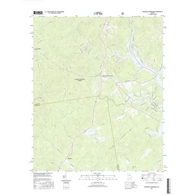
2017 Map of Resseaus Crossroads
USGS Topo · Published 2017About this map
Resseaus Crossroads serves as a central point in this transition zone between Oconee National Forest and the northern reaches of Lake Sinclair. The landscape is defined by the winding paths of Murder Creek and Big Cedar Creek, which carve through the timberlands and small settlements like Stanfordville and Ethridge. For those tracing local families, the map marks several burial grounds including Key Cem near the crossroads and Stiles Cem further south. The proximity of Upper Hawkins Lake and Lower Hawkins Lake suggests the importance of local water management and recreation in this part of Middle Georgia. The intricate road network, featuring routes like Stiles Cemetery Rd and Stanfordville Rd, illustrates the persistent connectivity between rural homesteads and larger regional hubs.
Find a feature on this map
75 named features on this map. Tap any name to fly to it.
Don’t see what you’re looking for? This feature index may not catch every label — zoom into the map to look around manually.
Map Details
Editions of this 2017 Resseaus Crossroads Map
This is the sole edition of this map. No revisions or reprints were ever made.
Other maps of this area

1953 · Athens
USGS Topo · 1:250,000

1958 · Athens
USGS Topo · 1:250,000

1959 · Athens
USGS Topo · 1:250,000

1963 · Athens
USGS Topo · 1:250,000

1964 · Gray
USGS Topo · 1:24,000

1964 · Stanfordville
USGS Topo · 1:24,000

1972 · Meda
USGS Topo · 1:24,000

1972 · Eatonton
USGS Topo · 1:24,000
1972 · Smithboro
USGS Topo · 1:24,000
1972 · Browns Crossing
USGS Topo · 1:24,000